

BBIM | MergeProject Patch not separating elements in different buildings

I have two dummy projects, building1 and 2 saved in their respective .ifc file
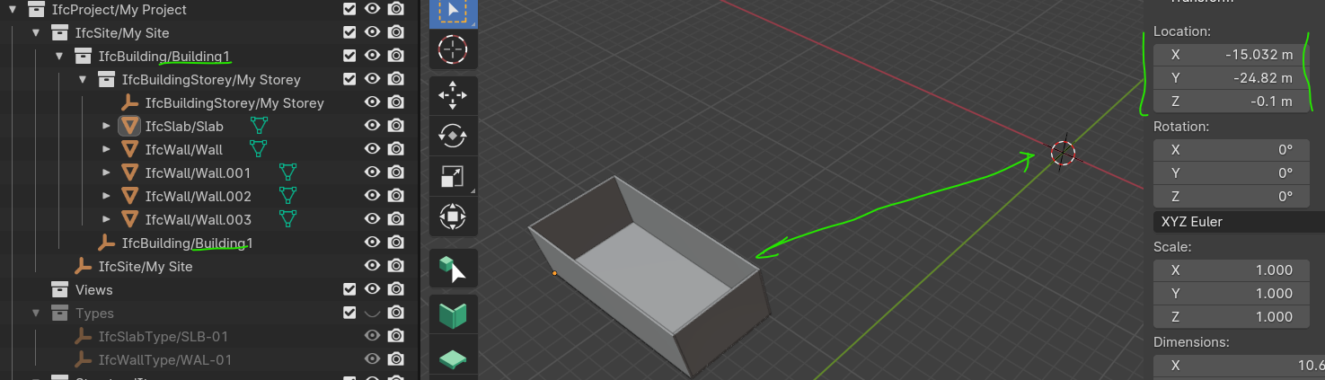
this is building 1:
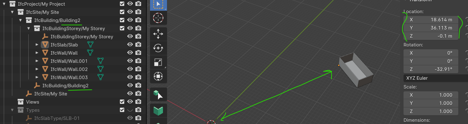
and building 2:
now I'd like to use the patch MergeProject to make one single .ifc file with both buildings..
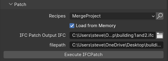
to do that I run the patch from building1.ifc, thick the Load from Memory box and set the output file as building1and2.ifc, the to-be-merged file being building2.ifc, before clicking on the Execute button.
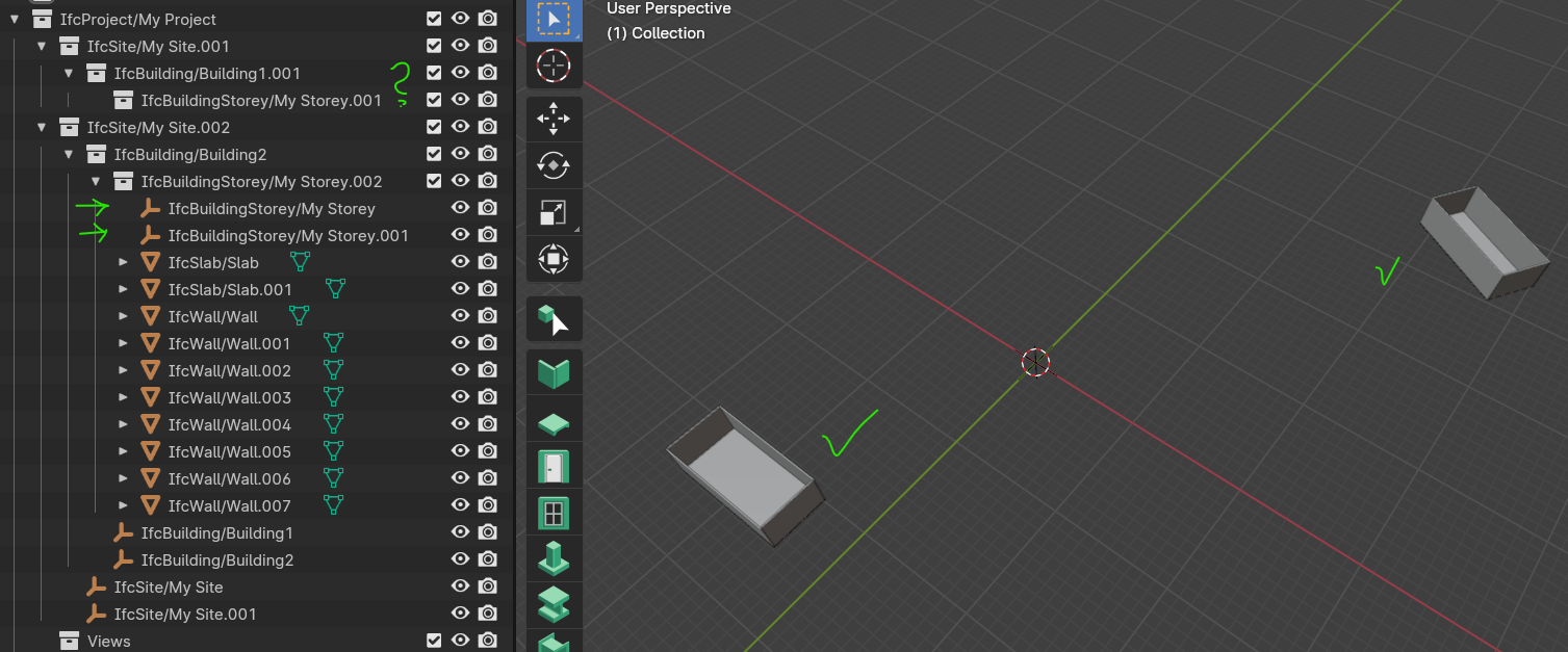
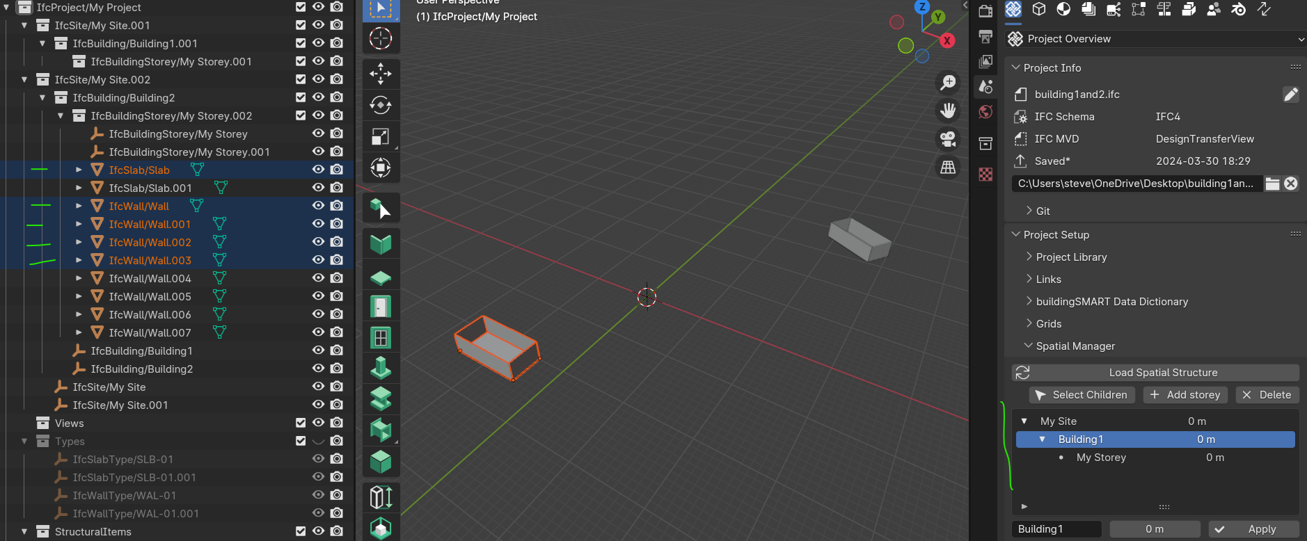
Here is building1and2.ifc with the two buildings properly located:
BUT..
I was under the impression that the patch would duplicate all containers preserving the relations of elements/buildings, instead I have what looks like one building (2) with all elements together
Furthermore, when I open Spatial Manager I can only see Building1 and select its elements, though in the Outliner they are all in building2's container, odd.
please what is the correct way to use this patch?
.ifc files attached..
thanks for your help and Happy Easter (or holidays)


Comments
And to add to your issue how does Georeferencing play out in all this assuming these 2 buildings have to be in georeferenced positions relative to each other. Can someone really help out in georeferencing in BBIM? I have been unsuccessful anytime I try coordinating with my structural engineer who exports his .ifc from Revit.
EDIT (good news)
as suggested by @Bimlooser I found out the source of the weird behaviour
it's because, to test the patch, I used the same object shifted and saved using a different file name (and building name)
At least now I know that, in a situation where I do not use previous elements saved with different name, the patch works as expected..
@Owura_qu maybe the BBim doc can help
https://blenderbim.org/docs/users/georeferencing.html
Also this video can help
Yes I have come across this but I still experience some challenges and besides not all the tools under the BBIM Georeference are explained in the doc. May be a little update explaining what each tool does in the doc might help.
same here, I posted it some time ago as well
my need for instance is to be able to separately work (modelling) on different buildings using their local coordinates (grid lines A/1 x,y = 0,0) but knowing their World coordinates too (A/1 has in addition its own, in my case, UTM30N coordinates and Y-axis rotation from True north) so that I can use/import/link/federate them in a larger model hosting multiple buildings, maybe with a road or bridge nearby.
If possible it would be awesome for presentations, leveraging on animations and rendering, similar to what Infraworks does.
Alternatively I use only mockup version of the buildings (outside shell only) placed according to the site map, but actual building models would be much better, especially with variations and similar..
Exactly! You are just speaking my mind and possibly many others. Maybe this georeferencing thing might be so simple to others but for some of us until our proficiency in BBIM and knowledge of IFC go past the ‘essentials’ to the ‘intermediate’ level these basic questions will keep coming.
The docs are inadequate and YouTube academy has been insufficient so a little attention to this georeferencing thing might be very much appreciated.
I need a Georeferencing for Dummies!
I think the main source for the issue is that IfcBuildingStorey in both files has the same guid and therefore ifcpatch assumes it's the same storey. You can regenerate guid for that storey in any of the files and merge will add elements to separated storeys.
I've exposed to BBIM UI button to regenerate guid that should help. See example - https://imgur.com/a/mvRtyER
Much needed indeed
For me working in the two worlds (horizontal with rail tracks & roads, vertical with buildings and infrastructures) is always a georeferenced drawing, in my case UTM-30N or EPSG32630
Details of buildings, since they can be used more the once in the same project, come as typical drawing with local coordinates (not georeferenced), if needed I can pick the block or entire DWG and place/rotate it where used in the horizontal (georeferenced) representation, easy to achieve in Civil3D and QGIS
A typical example, my current pain at the moment in BBIM, is where I have a yard with several buildings, access road, a bit of railway reaching the place, a few hectares at the most.
Since I (happily) use BBIM to model the buildings and run QTO on them, the exercise starts with a single building in local coordinates, all is fine as long as it stays there. But the Site as a whole contains those buildings together and here comes the hurdle.
I have a Project, one Site, one or more buildings with one or more storeys. Can I model them separately and place them together using their georeferenced information so my quantities can be generated accordingly? maybe use the lot for presentation? If the answer is yes, how to perform it in BBIM?
The Merge patch, to the best of my knowledge, uses local coordinates, do I have to apply transformation before it? The site is generated in georeferenced coordinates but it might be converted to "local" too if needed, so long there is a chance to use it with the coming buildings.
It would be great to see a very simple and practical example here, I can provide the basic dummy plans if needed
cheers!
PS hopefully the final result should be visible with a normal viewer ;-)
PPS I think the same issue is with real estate development design, not just with railway projects..
thanks Andrej, much appreciated