For this project, every one of these houses was a linked aggregate--which in turn had many nested aggregates (some linked aggregates) inside it.
...
I bastardized IfcBuildingStorey, only because of this wasn't possible yet.
...
When the outliner is organized by IfcBuildingStories and Aggregates, it gets muddy obviously when you have an aggregate as big as a house, that transcends multiple stories. IfcBuildingStories in this scenario become unusable. Not sure what the answer is. I just have a user case. :)
FreeCAD will now by default export groups nested in building structures as assemblies. The option is still there to disable this, though, to try to prove our point :) https://github.com/FreeCAD/FreeCAD/pull/14094
@yorik said:
FreeCAD will now by default export groups nested in building structures as assemblies. The option is still there to disable this, though, to try to prove our point :) https://github.com/FreeCAD/FreeCAD/pull/14094
Should the original behaviour be proposed to BuildingSmart (?) for consideration?
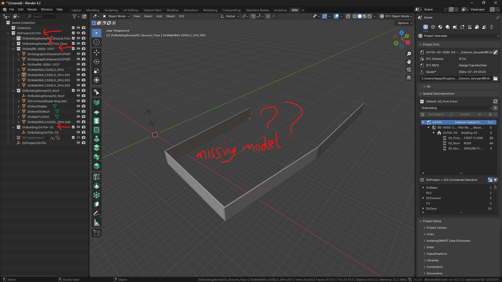
I installed "blenderbim_py311-0.7.11-alpha240730-windows-x64" in Blender 4.2 but when I opened my .ifc file most part of the building model is not showing. I observed in the Blender Outliner that the IFC aggregation tree has been disorganized. But when I open the same file with old BBIM-addon in Blender 4.1 there's no problem so I am bringing to attention if this could be a bug in the Blender 4.2.
Find the attached image to see the disorganized ifc tree (IfcProject-->IfcBuildingStorey-->IfcSite-->IfcBuildingStorey-->IfcBuilding) in the Outliner.
Thank you
The latest version purposely does not have a hierarchical tree in the outliner, it is now flattened on purpose. If you want to see a hierarchical tree, check out the new spatial decomposition panel (middle right of your screenshot).
If you have missing objects please urgently submit this as a bug and if the file is private share to [email protected]
@Moult said:
The latest version purposely does not have a hierarchical tree in the outliner, it is now flattened on purpose. If you want to see a hierarchical tree, check out the new spatial decomposition panel (middle right of your screenshot).
If you have missing objects please urgently submit this as a bug and if the file is private share to [email protected]
Okay, and good to know we have a new way of working now with the outliner. Kindly find the file for your audit.
Your model is there, it just so happens that you've managed to get some of your model very far apart from the rest of your model (specifically, those 4 walls and your IfcSite). Not entirely sure how this happened - did you perhaps use the OffsetObjectPlacements recipe at some time in the past? BBIM naturally tries to pick some sort of origin (because it can't show everything) and so the rest of your model looks "missing".
You can see in this screenshot that it's picked a particular easting / northing as a Blender origin, and waaaaay off to the north west is your actual IFC origin. You can disable georeferencing if you want to see the rest of your model, but really this needs fixing.
I have not used the OffsetObjectPlacements (I guess from the Patch tools you mean). I was working normally and everything was fine until I upgraded to the Blender 4.2.
I have removed the Georeferencing as suggested by main build model still not showing. But I still see the “Temporary Offset Is Active” still displaying Easting/ Northing values but I can’t find how to remove that. I do I get this done? Thank you.
I believe I have found the cause of the problem and the reason for the “Temporary Offset Is Active”!
It is because of the use of BlenderGIS (Web geodata >>>Basemap (Google)>>>Get Elevation (SRTM)) which I always use to generate my topography.
Normally after obtaining the topography using the BlenderGIS I convert it to “IfcGeographicElement[TERRAIN]”. I repeated the process in the Blender 4.2 again and save the file and closed;
1. But when I reopened it the topography (IfcGeographicElement) again was missing from the workspace so selected it in the Outliner and browsed View>>>Frame Selected and was able to now zoom-in to it.
2. Then I moved the 3D cursor to the basepoint of the IfcGeographicElement and when I compared the x,y coordinates to the Eastings, Northings values of the “Temporary Offset Is Active” (under tab Georeferencing >>>Blender Cooredintes) it was the same!
But my question still remains how do I remove the “Temporary Offset Is Active” and reset to default values (0,0)?
I've manually shifted back your site and building (and the walls on the site) back to 0,0,0 to fix your model. However there is clearly something I still don't understand about your workflow with BlenderGIS. Can you join the OSArch live chat and we chat screenshare so I can see what's happening?


Comments
I bastardize assemblies then. ;)
Actually that might be the best idea so far :)
For this project, every one of these houses was a linked aggregate--which in turn had many nested aggregates (some linked aggregates) inside it.
...
I bastardized IfcBuildingStorey, only because of this wasn't possible yet.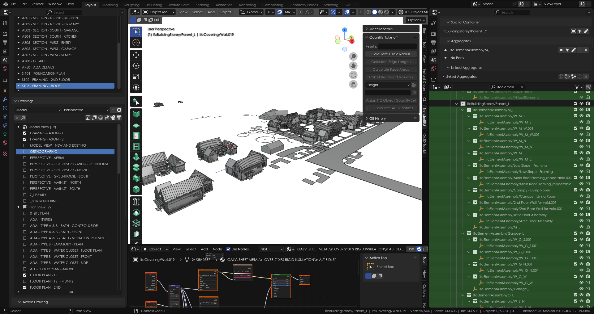
...
When the outliner is organized by IfcBuildingStories and Aggregates, it gets muddy obviously when you have an aggregate as big as a house, that transcends multiple stories. IfcBuildingStories in this scenario become unusable. Not sure what the answer is. I just have a user case. :)
I've tried to delete them but I've failed, the entitities disappear but when i close end reopen the file they recreates.
Sorry, I've understood I had to use the "IFC delete" button, not the simple "delete" button
FreeCAD will now by default export groups nested in building structures as assemblies. The option is still there to disable this, though, to try to prove our point :) https://github.com/FreeCAD/FreeCAD/pull/14094
Should the original behaviour be proposed to BuildingSmart (?) for consideration?
I installed "blenderbim_py311-0.7.11-alpha240730-windows-x64" in Blender 4.2 but when I opened my .ifc file most part of the building model is not showing. I observed in the Blender Outliner that the IFC aggregation tree has been disorganized. But when I open the same file with old BBIM-addon in Blender 4.1 there's no problem so I am bringing to attention if this could be a bug in the Blender 4.2.
Find the attached image to see the disorganized ifc tree (IfcProject-->IfcBuildingStorey-->IfcSite-->IfcBuildingStorey-->IfcBuilding) in the Outliner.
Thank you
The latest version purposely does not have a hierarchical tree in the outliner, it is now flattened on purpose. If you want to see a hierarchical tree, check out the new spatial decomposition panel (middle right of your screenshot).
If you have missing objects please urgently submit this as a bug and if the file is private share to [email protected]
Okay, and good to know we have a new way of working now with the outliner. Kindly find the file for your audit.
Thank you.
Your model is there, it just so happens that you've managed to get some of your model very far apart from the rest of your model (specifically, those 4 walls and your IfcSite). Not entirely sure how this happened - did you perhaps use the OffsetObjectPlacements recipe at some time in the past? BBIM naturally tries to pick some sort of origin (because it can't show everything) and so the rest of your model looks "missing".
You can see in this screenshot that it's picked a particular easting / northing as a Blender origin, and waaaaay off to the north west is your actual IFC origin. You can disable georeferencing if you want to see the rest of your model, but really this needs fixing.
I have not used the OffsetObjectPlacements (I guess from the Patch tools you mean). I was working normally and everything was fine until I upgraded to the Blender 4.2.
I have removed the Georeferencing as suggested by main build model still not showing. But I still see the “Temporary Offset Is Active” still displaying Easting/ Northing values but I can’t find how to remove that. I do I get this done? Thank you.
I believe I have found the cause of the problem and the reason for the “Temporary Offset Is Active”!
It is because of the use of BlenderGIS (Web geodata >>>Basemap (Google)>>>Get Elevation (SRTM)) which I always use to generate my topography.
Normally after obtaining the topography using the BlenderGIS I convert it to “IfcGeographicElement[TERRAIN]”. I repeated the process in the Blender 4.2 again and save the file and closed;
1. But when I reopened it the topography (IfcGeographicElement) again was missing from the workspace so selected it in the Outliner and browsed View>>>Frame Selected and was able to now zoom-in to it.
2. Then I moved the 3D cursor to the basepoint of the IfcGeographicElement and when I compared the x,y coordinates to the Eastings, Northings values of the “Temporary Offset Is Active” (under tab Georeferencing >>>Blender Cooredintes) it was the same!
But my question still remains how do I remove the “Temporary Offset Is Active” and reset to default values (0,0)?
I've manually shifted back your site and building (and the walls on the site) back to 0,0,0 to fix your model. However there is clearly something I still don't understand about your workflow with BlenderGIS. Can you join the OSArch live chat and we chat screenshare so I can see what's happening?
Thank you for fixing it and I hope to get more insights for the troubleshoot. I have joined the live chat so when you are ready.