I want to try my hand at doing a small infrastructure project using only free and open source software. Which softwares would you recommend for me to use on my stack?
You'll probably need to provide more detail - what discipline, how big is the infrastructure? (e.g. > 1km or < 1km), required deliverables (drawings? models? simulations?), etc.
Good point, this is mostly a challenge that I want to do, but I'm thinking about a small bridge, few hundred meters over a river, no deliverables other than the model which needs to be IFC 4.3. The terrain itself is mostly irrelevant as I will probably pick a river somewhere and make a random bridge. Need to get at least the shape of the structure and foundations, no rebars or pre-stressing cables needed.
EDIT: Would the stack change if the project go bigger, let´s say 5km? Just wondering, in case I ever decide to make something more.
Thank you for your offer Walpa, really and truly. But I am looking for the challenge of doing the modelling myself and trying to get to an actual standard. This post is mostly to see where my starting point can be. As a BIM Manager with paid software and working for a company, I've always had "this is the project, here is the base data that we got from somewhere", but I'm fishing for that extra "can I do an infra project 100% free and open source?". I'm still trying to get the idea of where that project should go lol.
Well if you want to see all the aspects of a project you might as well begin at the start. When we construct a bridge, it is to connect points of interest, regions, cities, industries by overriding a longer route. What purpose would your bridge serve ? Do you want it to support pedestrians ? Bicycles ? Heavy duty traffic ? This will give you ideas and guide the constructive solutions you should aim for. I suggest you read material about bridge construction, the history of bridges and why they are designed that way if you have no engineering / structural background. This for example
Note a few hundred meters span already places your bridge into the realm of megastructure projects (IMO), so this might not be the more suited for a first dive into a brand new world. :)
I'm an engineer, Civil, but never worked on the design part only on site. That said, the last bridge that I worked on was a 200m bridge (length, not height, just to be clear) and it wasn't even close to a mega project (imo, mega projects are projects that cost at least 200.000,00 €). I work now as a BIM Manager in a company that specializes in building bridges, that's why I wanted to design a bridge specifically.
@walpa said:
I didn't do the IFC modeling, because I left that work.
Memory "plays tricks" on us sometimes... :), I even did IFC modeling.
I'll leave the IFC file in case someone needs an example in the future. @NickNunes I understand your proposal, I started a challenge like this a year ago for another type of infrastructure and to this day I am still lost in several ways...
As you are a BIM manager, I consider that you know the difference between designing and modeling.
If you need to model for planning, costs, etc., BlenderBim is your alternative.
In the model I made, I also needed FreeCAD to model the I-beams, as my knowledge of Blender at the time was not sufficient.
If you are going to design, including calculations, and do "simultaneous engineering" with the BIM model, then you may not find free and open source alternatives. Perhaps colleagues on this Forum can point out a way forward.
I found this material that helped me a lot with modeling.
I think we're coming up short in the FOSS realm when it comes to infrastructure modeling. For example, there is currently no interface I know of that can author an alignment curve. FreeCAD is likely more advanced when it comes to modeling this type of solid geometry I think. So long as you're under 1km I think georeferencing-wise both Blender and FreeCAD are OK.


Comments
You'll probably need to provide more detail - what discipline, how big is the infrastructure? (e.g. > 1km or < 1km), required deliverables (drawings? models? simulations?), etc.
Good point, this is mostly a challenge that I want to do, but I'm thinking about a small bridge, few hundred meters over a river, no deliverables other than the model which needs to be IFC 4.3. The terrain itself is mostly irrelevant as I will probably pick a river somewhere and make a random bridge. Need to get at least the shape of the structure and foundations, no rebars or pre-stressing cables needed.
EDIT: Would the stack change if the project go bigger, let´s say 5km? Just wondering, in case I ever decide to make something more.
I was on a construction site (Brazil) last year and started modeling a viaduct as a test:
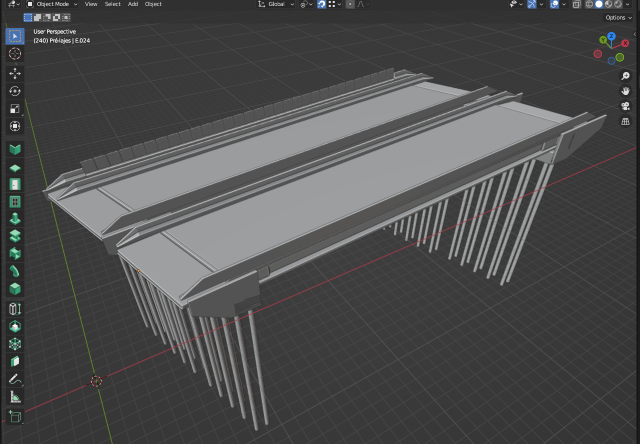
I only used Blender for the 3d geometry.
I didn't do the IFC modeling, because I left that work.
If you wish, I leave the blend file here.
Thank you for your offer Walpa, really and truly. But I am looking for the challenge of doing the modelling myself and trying to get to an actual standard. This post is mostly to see where my starting point can be. As a BIM Manager with paid software and working for a company, I've always had "this is the project, here is the base data that we got from somewhere", but I'm fishing for that extra "can I do an infra project 100% free and open source?". I'm still trying to get the idea of where that project should go lol.
Dito isso, muito obrigado pela sua oferta ;)
Well if you want to see all the aspects of a project you might as well begin at the start. When we construct a bridge, it is to connect points of interest, regions, cities, industries by overriding a longer route. What purpose would your bridge serve ? Do you want it to support pedestrians ? Bicycles ? Heavy duty traffic ? This will give you ideas and guide the constructive solutions you should aim for. I suggest you read material about bridge construction, the history of bridges and why they are designed that way if you have no engineering / structural background. This for example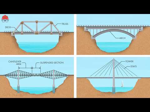
Note a few hundred meters span already places your bridge into the realm of megastructure projects (IMO), so this might not be the more suited for a first dive into a brand new world. :)
I'm an engineer, Civil, but never worked on the design part only on site. That said, the last bridge that I worked on was a 200m bridge (length, not height, just to be clear) and it wasn't even close to a mega project (imo, mega projects are projects that cost at least 200.000,00 €). I work now as a BIM Manager in a company that specializes in building bridges, that's why I wanted to design a bridge specifically.
Memory "plays tricks" on us sometimes... :), I even did IFC modeling.
I'll leave the IFC file in case someone needs an example in the future.
@NickNunes I understand your proposal, I started a challenge like this a year ago for another type of infrastructure and to this day I am still lost in several ways...
As you are a BIM manager, I consider that you know the difference between designing and modeling.
If you need to model for planning, costs, etc., BlenderBim is your alternative.
In the model I made, I also needed FreeCAD to model the I-beams, as my knowledge of Blender at the time was not sufficient.
If you are going to design, including calculations, and do "simultaneous engineering" with the BIM model, then you may not find free and open source alternatives. Perhaps colleagues on this Forum can point out a way forward.
I found this material that helped me a lot with modeling.
I won't be doing any calculations, just the modeling itself. Again, just for the challenge.
I think we're coming up short in the FOSS realm when it comes to infrastructure modeling. For example, there is currently no interface I know of that can author an alignment curve. FreeCAD is likely more advanced when it comes to modeling this type of solid geometry I think. So long as you're under 1km I think georeferencing-wise both Blender and FreeCAD are OK.