

Difference between Grid and True North
I think we should use and talk about Grid North **and **Project North. And forget about 'True North'. In Revit True North is Grid North and Geo-positioning can be challenging enough with just one 2 north, We don't need three. Is this something BuildingSmart made up?
Comments
The purpose of true north is not for georeferencing. It's for:
Oh, and no, it's not something buildingSMART made up, it's a legitimate concept. For example if you had a solar-north aligned map projection like WGS 84, then true north = grid north, but most other map projects will see a deviation.
There's also magnetic north which also exists, but it doesn't exist in IFC because it serves no useful purpose (what with wandering around all the time).
I think i would be using the same value for both Grid and 'True' North. Rotation for Just north as one important value.
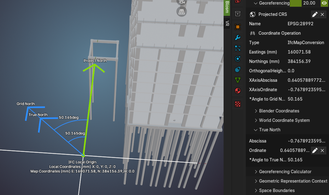
In some map systems grid north really doesn't align with longitude/true north:
If only the earth was flat, life would be so much easier. Wait you're saying it's not!
In Australia , they are also not the same. That's a fantastic image. Another way I like to demonstrate it visually is to draw a segmented vertical line in QGIS then change projections and watch how it becomes a curve and is no longer vertical.
from what I heard:
true north is the direction to the geographic north which in most cases roughly coincide with the grid north, much depends on the projection of the grid used, like the one nicely showed by @brunopostle
in UTM for instance it gets a bit tricky when you get closer to the edge of the zone but the two north are almost the same when at the center
for small projects True and Grid in most cases they practically tell the same story, the same when a high accuracy is not required
interesting topic, thanks
PS @Moult 's explanation is not just very hilarious, it's actually true :)
For the Netherlands the correction is only about half a degree. And Blender like all BIM software only use imagery and 'flat' content only, all based on a grid north situation. In respect to the argument of 'sun study' software is perfectly able to calculate the correction based on grid north position anywhere on the earth using EPSG code and rough position. Why bother users with it? Not something you would love to dive into. And the problem i see is in the naming . 'True North' can really confuse a lot of users. Revit calls Grid North True North. This might lead to putting the values in the wrong place. Miscommunication in the field. This fuzz can be avoided by using them both the same value. Nevermind the sun-study. Maybe there a (ISO) BIM standard that describes something and help us out?
IFC is an ISO BIM standard and it is using the correct terminology.
If Revit is using the wrong term, that is something for Autodesk to fix.
Autodesk 'fixing' this is not going to happen anytime soon. Which section are you refering to?
https://ifc43-docs.standards.buildingsmart.org/IFC/RELEASE/IFC4x3/HTML/lexical/IfcCoordinateReferenceSystem.htm
See also the subtype IfcProjectedCRS and IfcMapConversion.
I'm reading this as: defines the rotation in a flat situation. There is only one in IFC. Or am i missing something?
@magicalcloud_75 Do you mean you would like to be able to define a coordinate system that is not a flat projection ?
I only use CSR EPSG 28992. Thats for the Netherlands. I have no intention to use more than one CRS, nor more than one rotation for North direction. .. I think i made a clear point :)
Well judging by all the back and forth and after re-reading everything several times I beg to differ ><
Is this thread actually adressing a legitimate issue or asking a real question or is it just a rant about the semantics of the IFC schema regarding georeferencing ?
Well
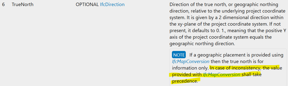
The earlier link was for grid north, true north is defined here: https://ifc43-docs.standards.buildingsmart.org/IFC/RELEASE/IFC4x3/HTML/lexical/IfcGeometricRepresentationContext.htm
Dion, if i edit the 'true north' value and save it as .blend file this value is not saved. Will be 0.0 after re-open it.
Nothing is saved in the .blend file so this is expected. See https://docs.bonsaibim.org/guides/troubleshooting.html#saving-and-loading-blend-files
Thanks for pointing that out. Saved as IFC it will saved!

As IFCDirection
Also, this note was given by BuildingSmart in case of inconsistancy! (which will happen..)