

[BlenderBim] How to change 0? / ground reference

Hi all, just wondering if anyone knows how to change the 0 / ground floor reference level?
I want to move the reference without moving all the elements, and for a new level to be set as 0.000
Tagged:
Comments
Hopefully this PR adds this functionality
Video here.
That's called lying ;)
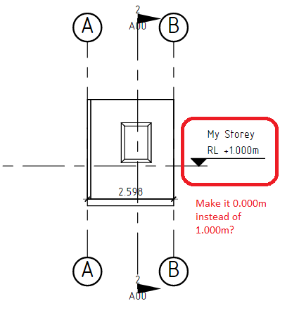
But in all seriousness, what's the usecase for this? There is a proposed fix https://github.com/IfcOpenShell/IfcOpenShell/pull/2451 which is not quite right as the ElevationOfRefHeight is a bit of a weird attribute with quirks of its own. I think it makes more sense to have an option where it is annotated with any custom arbitrary text, which if you wanted you can type in RL +0.000m if you wanted to. E.g. right now if you type in a description in the annotation.
I guess i'm trying to capture similar functionality to Revit, where you can change your levels to reflect feet/meters above sea level, for example.
Why go with an arbitrary text when it seems this concept is baked into IfcBuilding.ElevationOfRefHeight with IFC4, and with ElevationOfFFLRelative/ElevationOfSSLRelative with IFC4x3 and beyond?
Right, so I guess there are two possible elevations, the local engineering coordinate elevation (e.g. arbitrary Z value of your modeling software) or the true orthogonal height in the coordinate reference system (e.g. Australian Height Datum), in which case it should be Z + OrthogonalHeight in the MapConversion (which is the more correct way to supersede ElevationOfRefHeight). Is that perhaps the way to go? Does that solve your original problem @Ace?
Yeah, i could do that instead.
...
I wonder where ElevationOfFFLRelative/ElevationOfSSLRelative will come into play with these section level annotations, in the future?
Yeah in the future you'd be able to tag either FFL or SSL, and naturally the RL annotation line will adjust to one of those levels, whereas right now the RL annotation line is stuck to the IfcBuildingStorey's Z location.
In truth I've worked on multiple projects where the 0 datum changes because of some reason (before we hit site), most of the time it technically works better from a different spot or it's a 'political' decision, the other factor is when people just use the wrong datum to start the project when there is a split level, so I think it would be nice if it could be adjusted :)
This is perfect @theoryshaw
@Ace yeah, looking to the future we can aim to do better. One of the reasons people fake this is because it's hard to change in existing software. But if our software makes it easy (e.g. moving a level is easy, and also doing the OffsetObjectPlacements patch is easy) then hopefully we can push to more correct modeling.
However if the usecase is offsetting due to known map coordinates orthogonal height, that should be supported. I'll find some time to go through @theoryshaw's PR.
I think so?
The height from Sea level is absolute, the project itself isn't shifting up or down, I just want to change the project 0 datum so that when they start building it is from where the new 0 position is agreed