

BlenderBIM+BlenderGIS for archaeological case study

Hi! A couple of months ago I reached out to this community for help while I was working on my PhD thesis. Everyone was really helpful and friendly, and I have learned a lot. For this reason, I wanted to link you the first of (I hope) various articles I wrote about my project and how I used BlenderGIS and BlenderBIM to create a 3D archaeological map in Blender. Any comment or suggestion is welcome. You contribution was really valuable to me, so the OSArch community is mentioned in the aknowledgments.


 and 4 others.
Comments
Cool! If you think about it, archaeology is really just Life Cycle Management taken to the extreme :D
It is awesome to see yet another application of the IFC schema ! Thank you for sharing. That's not a BIM model you see everyday :)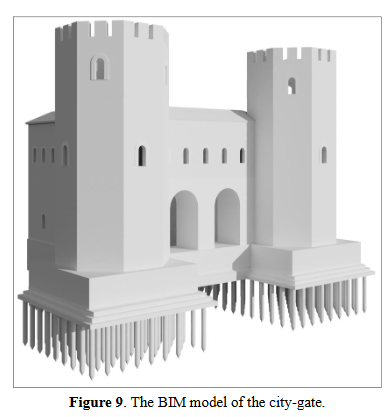
Taken from your article.