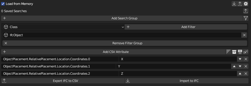
Can I get X, Y,Z coordinates for objects using this tool?.
Looking selector-syntax documentation seem possible but I tryed without success (maybe syntax or property I use is wrong).
Hi c4rlosdias, it works.
teoryshaw, this syntax doesn't work.
I tryed to formafting the coordinates with syntax like metric_length(x,0.01,2) and fail too.
thanks for the answer.
@c4rlosdias 's answer is correct, because it will fully resolve all relative coordinates, whereas @theoryshaw 's answer will only get the leaf relative coordinates.
Extracting the location is working really nicely. How about setting the position from the csv when reimporting? I get an error for that (I know, great power to mess up the model) and it should be fairly easy to create a script that can achieve this but doing this with ifccsv would be really handy.
@tobenz said:
Extracting the location is working really nicely. How about setting the position from the csv when reimporting? I get an error for that (I know, great power to mess up the model) and it should be fairly easy to create a script that can achieve this but doing this with ifccsv would be really handy.
Added support for this in this commit, you can try it out in the latest build.
Awesome quick response! I created an issue on gh because the new position is not automatically shown in blender. It would also be great if the rotations (which are not that easily retrieved from the IFC file itself) could be set with this.
This allows us to have a nice workflow where we "sync" element position in qgis for alignments (with the station & offset plugin) and their position in IFC. Plan sheets created in QGIS (only symbols needed), SVG/PDF export from there. Best of two worlds ;)
This allows us to have a nice workflow where we "sync" element position in qgis for alignments (with the station & offset plugin) and their position in IFC. Plan sheets created in QGIS (only symbols needed), SVG/PDF export from there. Best of two worlds ;)
I am using QGIS quite extensively to, among other things, run quantity take-off of railway projects, could you please elaborate your lines here a bit more ? It sounds very interesting but I am not sure if I got it right, thanks
guys please I need to extract these coordinates (absolute or global coordinates) I've tried thid ObjectPlacement.RelativePlacement.Location.Coordinates. argument but it gives relative one
I mean these coordinates (in the picture) that i want while using ifcCSV (or even if there is another tool)
@alaasquan said:
guys please I need to extract these coordinates (absolute or global coordinates) I've tried thid ObjectPlacement.RelativePlacement.Location.Coordinates. argument but it gives relative one
I mean these coordinates (in the picture) that i want while using ifcCSV (or even if there is another tool)
Can someone please help , I'll be so thankful !
did you try x or y as attributes ? they work fine in spreadsheet import export, I think ifcCSV is the same..


Comments
Would be interested in this as well
this work?
@c4rlosdias I like your's better! :)
Hi c4rlosdias, it works.
teoryshaw, this syntax doesn't work.
I tryed to formafting the coordinates with syntax like metric_length(x,0.01,2) and fail too.
thanks for the answer.
In 230902 this syntax doesn't work. If you need it, switch to 231104 version
@c4rlosdias 's answer is correct, because it will fully resolve all relative coordinates, whereas @theoryshaw 's answer will only get the leaf relative coordinates.
Extracting the location is working really nicely. How about setting the position from the csv when reimporting? I get an error for that (I know, great power to mess up the model) and it should be fairly easy to create a script that can achieve this but doing this with ifccsv would be really handy.
Added support for this in this commit, you can try it out in the latest build.
Awesome quick response! I created an issue on gh because the new position is not automatically shown in blender. It would also be great if the rotations (which are not that easily retrieved from the IFC file itself) could be set with this.
This allows us to have a nice workflow where we "sync" element position in qgis for alignments (with the station & offset plugin) and their position in IFC. Plan sheets created in QGIS (only symbols needed), SVG/PDF export from there. Best of two worlds ;)
Hi @tobenz
I am using QGIS quite extensively to, among other things, run quantity take-off of railway projects, could you please elaborate your lines here a bit more ? It sounds very interesting but I am not sure if I got it right, thanks
@steverugi qto with qgis sounds interesting to me. Maybe we can exchange our ideas about this on a week or two?
guys please I need to extract these coordinates (absolute or global coordinates) I've tried thid ObjectPlacement.RelativePlacement.Location.Coordinates. argument but it gives relative one
I mean these coordinates (in the picture) that i want while using ifcCSV (or even if there is another tool)
Can someone please help , I'll be so thankful !
did you try
xoryas attributes ? they work fine in spreadsheet import export, I think ifcCSV is the same..yes I did but it didnt give me unfortunately , but thank u anyways
here is in spreadsheet import export:
which generated
matching the coords
is this not what you need? I selected one single element using its GID but of course you can use class or else
I used to type x,y,z with capital letters , Now it works perfectly . Thank you so much , this is really helpful , i appreciate it!