

BBIM for Archaeological Excavations: Completed Master Thesis, now working towards Publication

One year ago, I asked for your opinons on using BBIM, and through it IFC and BIM, for the documantation of archaeological excavations, meaning all features we excavate, not just architecture. (https://community.osarch.org/discussion/comment/15775)
This was of interest to me, as I saw potential there and was looking for a topic for my master thesis. Many of you gave me encouraging feedback, and with some of you I exchanged more messages about this, seeking advice about various details.
Due to your encouragement and help, I finished my thesis on this topic, looking at BIM, IFC and BBIM theoretically first, before conducting and presenting an experimantal case study of an area I excavated in Ethiopia. A few weeks ago I graduated and am now looking into PhDs (with a very different topic though).
Having convinced my professors of the potential there is in BIM beyond Buildings (Archaeology Information Modeling (AIM), as I termed it in the thesis), they suggested presenting it at technologically themed archaeology conference and publishing the work I have done for my thesis.
To both give you guys an update, as previously promised, and to invite new feedback, here is a rough outline of my case study.
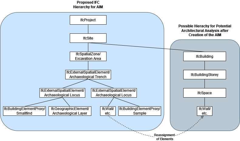
The hierarchy I employed was as depicted below, with user-defined subtypes for non-architectural pieces. All entities defined on excavations fit some broader IFC class, just for smallfinds and samples I had to use IfcBuildingElementProxies (even though they are not building elements).
For the features' geometric representation, I had ChatGPT write a script for importing coordinate points and offsetting them by the negative of the coordinates specified in the georeferencing, so they appear where they should. From these coordinates, I modeled simplified representations of every feature.
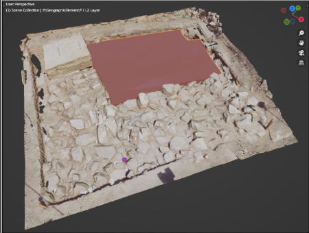
Other excavations, that document every feature in 3D (through laser scanning or photogrammetry) could use simplified versions of those models and save them in IFC. However, due to the high face count of these poligonal models and the importance of the realistic textures for documentation, not yet supported by IFC, I saved the 3D scans of features in .blend format to link into the project when desired.
In this way, all primary data was able to be saved in IFC, with custom property sets attached to the IFC objects. Other important digital documntation can be linked into the project if georeferenced and scaled correctly, and all other files produced can be referenced as attached documents. In this way, creating an excavation database with BBIM would have 3 layers of intergration.

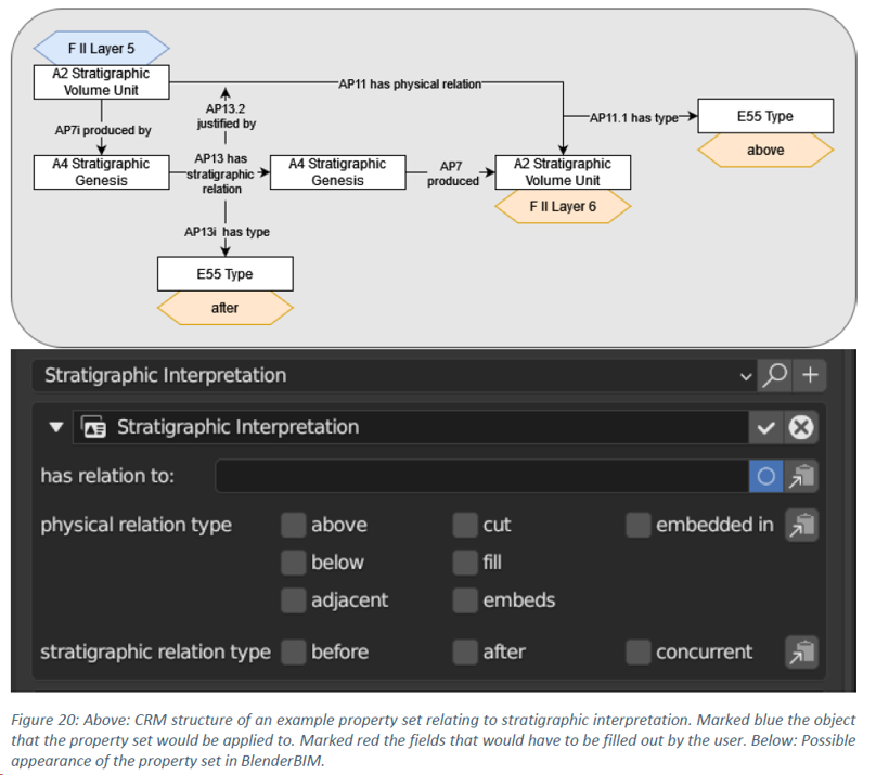
I also added a chapter of considerations on how to standardize the custom property sets for archaeology should people actually adopt a similar workflow, using ontologies that are already more established in archaeology.
For example:
Well, that is it really. Sorry for the long post, I hope some here might be interested. You guys really were of great help to me and I referenced this forum and some people from here multiple times in my thesis. If I ever publish something on this, you guys and the help you provided will definitely also be mentioned in the acknowledgements there.


 and 2 others.
Comments
I am interested in LiDAR, so I sometimes go to user cases and they are used in archaeological surveys, and the topic of digitization comes up.
I have seen it used for GIS and CityGML, but this may be the first time I have seen BIM.
I would like to see a future where AIM and CityGML are connected.
Yes, closer BIM+GIS integration would be super useful for this approach here, luckily some people are working on IFC+CityGML integration, but I did not yet look into it much
This is awesome work! Do you by any chance have a link to your publication?
Will link it here if/when it gets published. For now I am happy to share a private copy of my thesis (I did write it in english). Anyone interested is welcome to send me a private message with an email adress to send it to.