

Seeking Feedback: Combining GIS + BIM for Soil Contamination Visualization – Any Prior Art or Tools

Hi everyone,
I’m part of a small research duo (environmental + IT background) working on an exploratory workflow combining GIS and BIM for visualizing subsurface soil contamination in 3D. We're currently doing a technical proof of concept and would appreciate any insights, examples, or tooling suggestions from people who've worked on similar problems.
Context:
- We often receive environmental datasets during soil remediation projects, such as:
- Borehole logs (XY coordinates, depth intervals, pollutant concentrations – often Excel or PDF),
- Site plans or DWG/PDF maps,
- Tables showing pollutants like TCE, PCE per depth.
- Sometimes these boreholes lack spatial coordinates. We use QGIS to georeference the site plan and manually assign X/Y to each point. Elevation (Z) is taken from available DTM data or approximated early on.
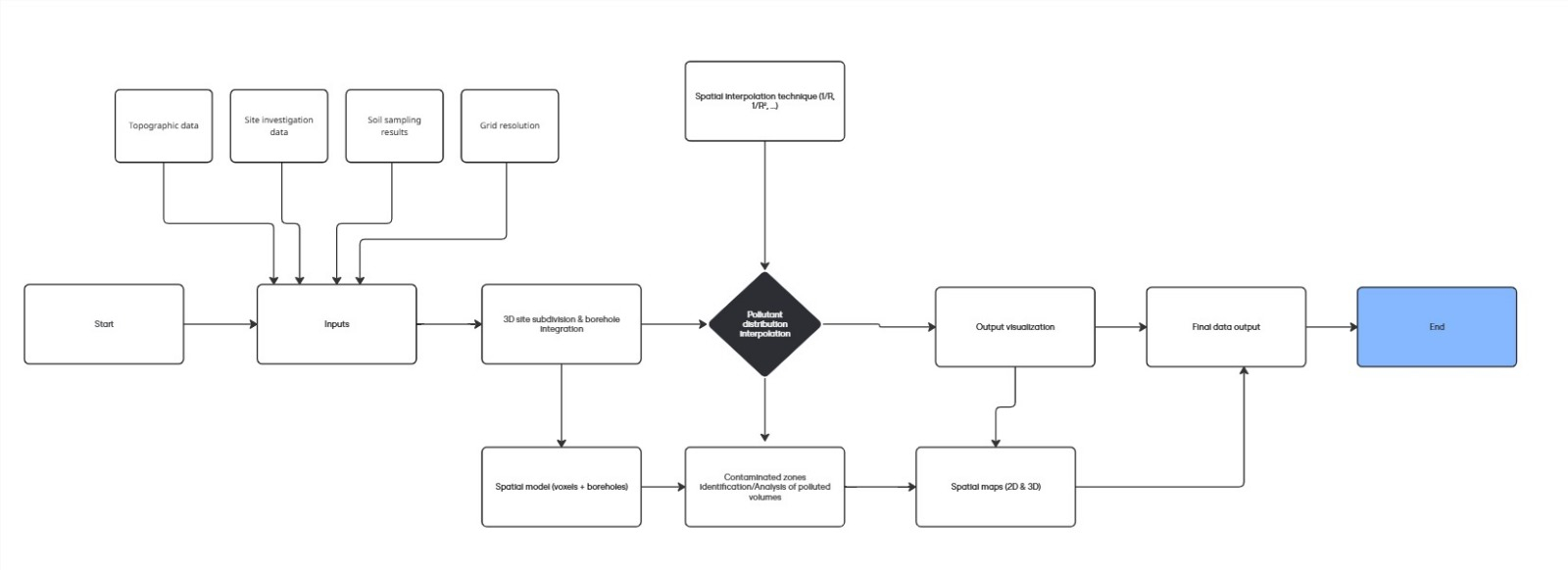
Conceptual Workflow (so far):
- Format data into a consistent structure (CSV with ID, X, Y, Z, depth, concentration, etc.)
- Model the topography
- Place boreholes in 3D
- Subdivide the site into a grid/mesh (soil blocks)
- Apply interpolation (e.g., linear) to estimate pollution spread
- Output 2D/3D maps showing pollution extents and volumes
Current Goals:
- Visualize contaminant plumes in 2D/3D
- Estimate volumes above regulatory thresholds (e.g., >1 mg/kg)
- Support remediation strategy planning
We’re not trying to develop a product at this stage — it’s more of a technical exploration of methods/tools. Ideally, we'd like to work with open-source technologies, support IFC/industry formats, and possibly make it browser-accessible.
Looking for Advice On:
- Best tools/libraries for 3D environmental data modeling?
- Thoughts on using Blender + BlenderBIM vs Revit or other?
- Appropriate interpolation methods for sparse borehole data?
- Any examples (academic or industrial) that tackled something similar?
How others have handled GIS ↔ BIM interoperability in practice?
We’ve found scattered examples but no full pipeline yet — so any ideas, links, tools, or even what not to do would be super appreciated!
Thanks in advance, and happy to clarify any point!


Comments
Interesting! have you tried BlenderGIS?
https://github.com/domlysz/BlenderGIS
I just wrote a guide on BlenderGIS and topography for the wiki page, but it is down right now.
1. I'd definitely stick with open source tools for this, I work with revit daily and don't see any benefits in using it in this case.
2. Do you actually need a 3D mesh model? You can achieve a lot with just plain gis, python and geolocated raster files - this would actually seem to be the perfect use case and you could probably do it all in one software.
3. If you really want a visual 3D model, I'd consider a voxel based workflow, it would allow you to generate sections showing contamination depth
4. Regarding interpolation algorithms, Sverchok has field nodes which should do what you need if I understand it correctly.