BlenderGIS height/terrain map to IfcSite using BlenderBIM

Does anyone have any experience getting a height/relief map of a terrain and exporting it succesfully to an IfcSite with the BlenderBIM add-on?
I tried the BlenderGIS add-on, but after watching a tutorial I can't manage to get a correct height map of certain parts of the Netherlands.
Tagged:
Comments
Personally i find Blender to be a blackbox when it comes to geo stuff. I would advice Qgis for getting DTM .
Hi Coen,
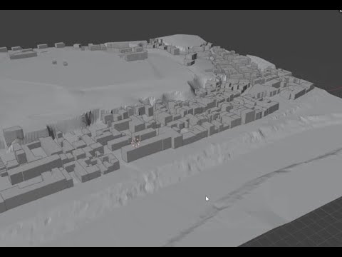
You can import a map terrain in an IfcSite in BlenderBim like any other object. You must create your terrain with BlenderGis (I use a "*.asc" file to create the mesh and add a orthophoto to texture in blender ). This mesh can be added to the ifc project like a building element proxy without problems. If the terrain is big, when you export this element to ifc format you get a big ifc file with the mesh (and losses the texture, or at least I don't know how to export it successfully).
You can see a sample (terrain about 15 km long) imported with BlenderGis and textured with orthophoto in this thread
https://community.osarch.org/discussion/comment/8287#Comment_8287
This one is not exported but I had done with other about 6 km long, getting a ifc file around 140 megas.
@Coen .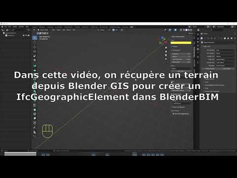
I might be far too late and irrelevant, but FYI. I made a short video on that subject (in french but i'm sure it's quite understandable without sound) -
Generation a terrain "leaf " in Blender3 BlenderGIS and copy/ paste to Blender4/BlenderBIM before assigning to the IfcGeographicElement Class. It seems to work fine.
See
Yesterday was a cold day, and i published this video that involves use of QGis and QGiq2ThreeJS to get a Terrain model usable in Blender and BlenderBIM. If you have access to DEM and relevant GIS vector data, you may use this method, it's a bit longer than the BlenderGIS method but i usually use this kind of process to have more precise data on smaller areas.