

BlenderBim import
BlenderBIM import problem.
Hey, is there anyone who know what this problem is about?
I would like to deliver a project to a client as an IFC model. Unfortunately, my program that I use to design models IFC export/import does not handle very well. Therefore, it would be great if I could import it into BlenderBim to continue to create a correct IFC project with good BIM. I belive that my client only is going to handle the model in a viewer so I guess that BIM info I add in BlenderBim will have some meaning since it is not going back to the origin software.
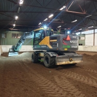
I build the project only with terrain models and 3D solids (except for some measurement) and get a pretty good result.
The terrain models I upload to my excavator for use in the machine guidance system.
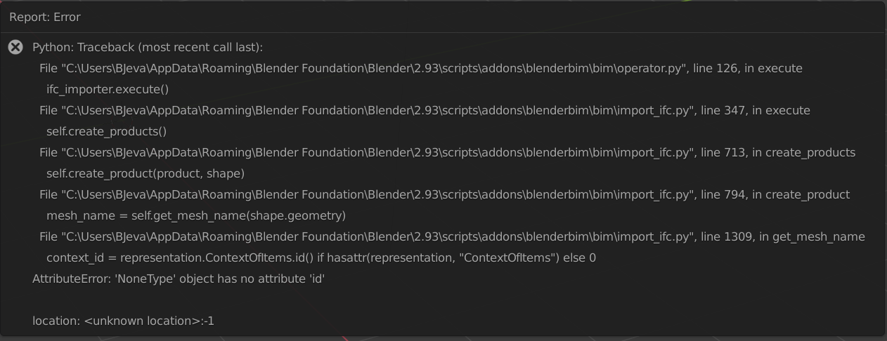
The solid model I save as IFC and that model works well in all IFC viewers that I have tried . BIMvision, Solibri, Trimle connect. It also opens in Freecad but looks very strange. In BlenderBIM it does not open at all but shows an error report as the screenshot below shows.
Since I struggle with everything that is digital, everything needs to be as simple as possible. Therefore, I feel that I must continue to build my terrain models in the software that I use today for the time being.
What is great about that software for me is that I construct directly in coordinates. I'm just setting the drawing to the right coordinate system, altitude system, map projection. And then I just start constructing based on my measured (in real time, on sight, with the excavator) points. The model ends up in the right place right away and I don't have to think about Georeferencing at all. And can instantly upload it to the machine guidance system in my excavator and start digging.
Wondering if this is what causes problems when importing into BlenderBIM, that my projects are created directly in the global coordinate system?
Comments
Generally speaking importing georeferenced models in single precision software (blender / 3dsmax ..) is not a good idea, you'll get precision issues, and may even not be able to navigate in 3d view.
However, as far as i'm aware, blenderbim will remove georeference, centering model to world, and store georeference in data.
@Benny there is nothing wrong working in absolute coordinates. The BlenderBIM Add-on will handle it and store a coordinate offset so that it can work within the Blender environment.
The error you get is unrelated. It seems as though a representation in your IFC data is missing a mandatory attribute. In other words, the IFC produced by your export is invalid. What is the software you use, and can you send me a copy of your IFC so that I can confirm my hypothesis? If indeed that is the case, can you get in contact with the software developers and ask them to fix it? The BlenderBIM Add-on is a bit stricter on this because it is one of the few IFC tools that has strong support for representation contexts, so that is why tools like BIMVision / Solibri don't have this problem, since they don't support representation context switching.
My email is [email protected] if your file is private. If you feel uncomfortable with sharing the file, we can also screenshare and debug on your own computer.
@Moult I can upload the file here. Even though I am new to this and have no background whatsoever in data etc, even I understand that the software I use does not handle IFC very well, but I think at least the most basic attributes should be in place. If you could describe what the problem is, I will be really happy and will of course ask the developers if they can fix it.
Just as a little information about the project, it will be a place for the motorhomes' can empty their sewage tank at the campsite located here in Västervik Sweden. I will probably build the hole thing by myself so it would be great if I at least could have a really really good IFC model.
The software I use is called Topocad and is developed by Adtollo.
Properties that I put in manually end up in the “Topocad attributes” tab.
When creating and exporting IFC models, I have virtually no opportunity to change, add, or delete information, there is like nothing to choose from. I can't even give the parts a name....Everyone gets the name "3Dsolid".
I also thought I'd take the opportunity to ask if anyone has a good idea about where to start if I would like to switch to opensource software eventually. I've started a bit with Freecad but haven't had time to look around all these work benches. It is this about being able to create good terrain models (Land XML) and in the right place in the coordinate system that seems quite difficult.
Ideally, I'd like to do everything in BlenderBim because IFC and BIM are really really fun and I'm a faithful follower of everything that's all about BlenderBim, BIMvoice, Building smart, etc.. I am clear that it is of course possible to manage my fairly simple projects in Blender . The problem is, of course, my own level of knowledge, and I hardly have the time or the energy to change it for the time being.
I would like to conclude by saying that you are doing an admirable job and I hope that in the future I will have the time and opportunity to contribute a little in some way.
@Benny yes, the file is quite invalid, and not something I think I should accommodate. Basically, the file contains no representation contexts, which is an even bigger problem than the lack of a reference to a representation context, and invalid names like "Facetation" used in their IfcShapeRepresentation. Feel free to forward the developers of the software this forum post which can help explain it to them.
Basically in IFC, geometry can only exist within a "representation context". This is quite a novel concept different to other simpler 3D formats, where a single object may have zero or more geometric shapes associated with it. For example, it might have a 3D shape, under the "Model, Body, Model View" context. It might also have a 2D shape under the "Plan, Annotation, Plan View" context. It might then have yet another shape under the "Model Center of Gravity Model View" Context. All of these geometries are equally valid and useful for different disciplines and usecases. Your file, unfortunately, specifies geometry, but has no context.
For viewing apps, who superficially only look at geometry, this isn't an issue. For authoring apps, like the BlenderBIM Add-on, this is quite a fundamental problem as no geometry can exist without a context.
Hope it makes sense.
I see IfcOpenShell in the header, suggesting that they are using IfcOpenShell. If so, perhaps we can help them - there are lots of tricks to quickly generate valid IFCs, especially with the new IfcOpenShell API that they might not be aware of. Perhaps we can collaborate with them to fix it!
@Moult Thank you very much! Yes it make sense , well explained.
I realy hope they pick up the thread at take the information that is available at this forum.
At least I will definitely try.
Thank you again!